

Hanson-Larsen Memorial Park -Cowboy Hill (M Hill)
- Ashley
- Mar 19, 2019
- 4 min read
Updated: Jun 19, 2020
Cowboy Hill (also known as M Hill) is a Rapid City landmark. On a sunny winter afternoon we decided to hike up to Hanson-Larsen Memorial Park's most well known attraction.
This destination was originally known as Cowboy Hill until the students of South Dakota School of Mines & Technology marked the top of the hill with a giant stone and cement "M" in 1912. The hill then became known by its new nickname, 'M Hill'. Located on the western side of Hanson-Larsen Memorial Park, this is one of Rapid City's most popular hikes.
We parked in the large Founders Park lot off Omaha Street. We crossed the bridge into the hiking area and took a left, heading up the main path. The wide trail is known as Cowboy Hill Road. When it curved uphill to the right we kept going straight, hopping on the T Trail.


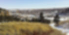
The River Trail and Rapid Creek flowed below. After a short walk, an interesting trail appeared to our right, heading uphill. This was the lowest portion of the Lower Rock Garden Trail (on some maps it's referred to as the 'Old Trail'). This 1,000 ft stretch intersects with Cowboy Hill Road, presenting several choices of where to head next. We took a left and continued upwards along Cowboy Hill Road.


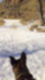
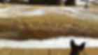
The trail conditions varied between packed snow and dirt, but was easy enough to traverse. There were interesting rock formations along the way. One should always be careful to watch for rock slides in this park -they have been known to happen from time to time.
M Hill is technically in the Chuck Lien Family Park, but it's all part of the same trail system. The same rules apply in this part of the park as they do in the other sections -pets must be leashed at all times (and please clean up after them).
Near the top was a large intersection with several other trails. We kept following the road up and to the left towards the summit of M Hill.


This moderately strenuous uphill climb seemed a bit daunting, but it's actually very pet-friendly. The trails were wide and well-traveled for the most part.
The iconic M at the top is over 100 ft tall and laid into the ground as a permanent fixture, visible from miles away. The M is actually lower than the summit of the hill. Several commemorative plaques adorn the hillside around the giant letter. A smaller "S" and "D" flank either sides of the M.
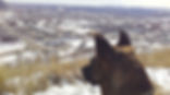
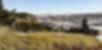
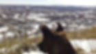
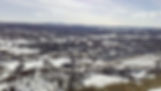
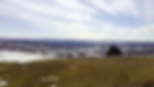
The top of the hill was wide and spacious. It provided great views of the city below and the Black Hills in the distance. Ursa especially valued the vistas of her kingdom spread out before her.


There was plenty of room for a water and treat break in the afternoon sun while enjoying the view. After having a rest and taking it all in, it was time to head out. There are many trails within the Hanson-Larsen System and several routes back down.
We started following M West, along the western side of the hilltop. After less than 1,000 ft the path ran into the Far West Trail. We followed this for only a short distance before taking a left at the start of the Upper Cliffs Trail.


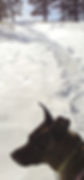
The Upper Cliffs Trail (which is referred to as the 'Cliffs of Dover' on some maps) wound down the hill along a rocky path. This stretch of trail contained the deepest snow we encountered during our entire trek. It followed the hillside down for about half a mile before reaching its end. Towards the bottom of the hill the signs refer to the Cliffs of Dover as the 'Lower Cliffs Trail'. There, it runs into the T Trail, just west of where we had turned off of it earlier.


We took a left, heading back via the T Trail before finally exiting on Cowboy Hill Road (making a giant loop in the process). Our entire trek was just over a mile and a half.


This was a really nice hike up and down the hill, as well as a good amount of exercise. The dogs had a great time. Maggie enjoyed rolling and playing in the snow whenever she got a chance. Ursa enjoyed looking out at the scenery below her as she climbed.
The hike up was along a wide path, which is always nice when walking two dogs together. The trail down, however, was much more narrow and a bit of a challenge (but still lots of fun).
This was a nice hike within the city, however, we do not visit here during the warmer months due to rattlesnakes. There are actual warning signs upon every main entry into the park, and I can personally attest to having seen one (it slithered across my path in the summer of 2017). We only hike here in cooler months, when conditions allow.
This is a popular place, and many people use the trails on any given day. It's a fun, moderately challenging hike with nice views from the top.
This was a great way to spend a sunny winter afternoon.


