

Cement Ridge Lookout
- Ashley
- Jun 26, 2019
- 4 min read


A remote mountain in the northwest corner of the Black Hills, Cement Ridge is home to truly spectacular views. Found approximately 2 miles inside the Wyoming border it's accessible only by navigating a series of dirt roads (which become snowmobile trails in the winter). The commonly used roads are fairly well maintained, but there are several different ways to reach the summit.

We started in Spearfish Canyon, and headed west on Roughlock Falls Road (also known as USFS Road 222). We passed Roughlock Falls, several different trailheads, and two forest service campgrounds. The road eventually came to an intersection with Tinton Road (a.k.a. USFS Road 134). We took a left at this intersection and then a right shortly after, onto Wagon Canyon Road (a.k.a. USFS Road 105) heading west.
I strongly encourage getting a good forest service map before attempting to navigate the maze of dirt roads in the Black Hills. Sometimes it can be tricky to find what you're looking for. Fortunately, the occasional sign for Cement Ridge does appear (I think we saw two the entire time).

USFS 105 continued from South Dakota into Wyoming. Shortly before reaching the border, we came across a peculiar cabin. Known as 'Saw Cabin', this aged and abandoned building has a roof made of old rusted saw blades. There's also a smaller shed with the same style roofing. It's fascinating but must be viewed from a distance as it's on private property.


A short distance past the cabin is another intersection. We took a right onto USFS Road 804 (now in Wyoming) and followed it until it intersected with USFS Road 850. A sign at this junction indicated that a right turn onto USFS 850 would lead us to the top of Cement Ridge. USFS 850 was the roughest part of the entire drive. In fact, many people park along it and hike to the top (this last stretch of road is only about 2 miles long). Armed with all-wheel drive and fairly high clearance we decided to try driving up, much to our success.


Cement Ridge Lookout is home to a fire tower, a public restroom, and several picnic tables. It's the highest peak in Wyoming's Black Hills. We walked around the hilltop, exploring all the fantastic views from the mountain.

The vistas were amazing; we could see distant wooded hills in all directions. We took our time looking out over everything before us.


Ursa was a bit taken aback by the scenery. At one point she simply decided to sit down and absorb it all in. She sat quietly, thoughtfully surveying the vastness of the world for a few minutes.


Cement Ridge is one of few "manned" fire towers in the Black Hills. Even though an actual person may not always be present, it is under 24 hour surveillance. Near the fire tower we found the survey benchmark, indicating we were officially 6,647 feet above sea level.


The mountain top picnic tables would make an amazing place to enjoy a meal. Inside the lower level of the tower was an additional picnic table hidden from the elements, as well as informational signs about the history of Cement Ridge. We learned that this fire tower was built in 1940 and 1941 by the Civilian Conservation Corps. In 1993 it was added to the National Historic Lookout Register.


We traversed the entire mountain top, enjoying the views from every aspect. The bare and rocky terrain lent itself to open vistas in all directions.


This was a beautiful and breathtaking place. It was easy to access, but not so easy to find. Reaching Cement Ridge was the culmination of a long ride through the gorgeous back roads of the Black Hills.


On the way back we decided to try a different route. We came down the mountain and reached the junction with USFS 804, but took a right. This headed west towards the fabled Black Hills Grand Canyon. The extensive geological formation stretches for miles and can be followed by taking USFS 804 west through Rattlesnake Canyon, then turning right onto Sand Creek Road (a.k.a USFS Road 863) and continuing north.

This route follows the western edge of the Black Hills and the series of red cliffs that make up its stunning geology. This was an amazing drive through some of the most remote and beautiful back country.

We passed by the Sand Creek Recreation Areas, several trailheads, and the historic Ranch A.

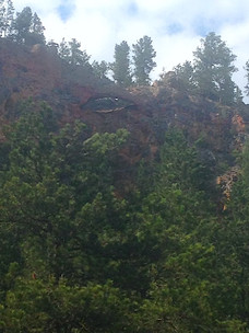
The Black Hills Grand Canyon is also home to one of the few natural bridges in the area. It can be found high along the canyon wall on the left side of the road (if you're headed north). It's not marked in any way; we really had to watch closely for it.

The entire drive through the Grand Canyon was magnificent. The road eventually came to an end at exit 205 in Wyoming, across Interstate 90 from Beulah, approximately 2 miles west of the South Dakota border.
From there the adventure could lead just about anywhere.


Comments