

Bogus Trail System -USFS 749.1A & Trail 6328 East (Loop)
- Ashley
- Jul 1, 2019
- 4 min read


There are a variety of different trail systems in the Black Hills of South Dakota. The Bogus Trail System is a fun and interesting one. It's built like a maze; many paths intersect with each other, not all paths are marked, and some simply dead end. Some of the trails are deceiving and lead deep into the forest before coming to an abrupt stop. It's worth doing some research on the area before heading out, or better yet bring a National Forest Trail Map. That being said, it is a really enjoyable place to hike and explore (assuming you don't get lost).


There are many ways to access the Bogus Trail System. We started at a small pull off along Highway 44, just west of Johnson Siding. This spot is known as the trailhead for Bogus Trail 6301 (which we had explored on a previous adventure to Trail 6332). From the parking area we already had a choice -left up Trail 6301 or right along old USFS Road 749.1A. We chose to start by going right, and had to cross a small bubbling spring to begin our expedition.


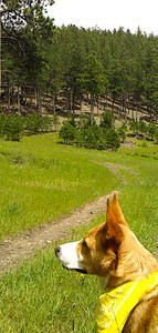
On a cool, windy day the dogs were eager to get out into the forest and do some exploring. USFS 749.1A wound through a lovely section of the woods for a beautiful walk. After a short while the trail took a turn deeper into the forest and headed up a fairly steep hill. Our hike suddenly became strenuous as we trudged up the mountainside. Halfway up the hill we'd been climbing, the road seemingly came to a dead end.


Piles of brush and downed trees blocked our direct route up the hill. We were now halfway up a 5,000 ft mountain with a decision to make. This was the perfect time to catch our breath, take a water break, assess our surroundings, and make a plan.

During our break a noticeable trail appeared. Where USFS 749.1A ended, a faint footpath continued up the steep hillside. Slightly to the right of the dead end, other people had kept going. This unmarked trail led the rest of the way up the incline to the top of the ridge. This part of the hike was strenuous, and is not suited for all dogs (or all humans for that matter). It was demanding and tiring, but was still a fun hike up the wooded mountainside. The girls led the way bravely and enthusiastically to the top of the slope.
At the top of the ridge we ran into Bogus Trail 6305. We now had a choice to make of heading right or left along it. The trail to our right continued around the hillside to the southeast. However, an unmarked spur trail led the rest of the way up the hill's eastern summit. This caught our eye and we followed it, finishing our climb up the mountain we had been trudging up.

At the top we found beautiful views of the hills to the east. This was the perfect place to take a nice break. There was room to sniff around and enjoy the scenery while having a treat in the shade of the large evergreens.


We rested for a little while, until the girls were ready to keep hiking. We made our way back down the spur trail and onto Trail 6305. We continued northwest (or left) along the trail, which followed the top of the ridge. It was thickly wooded with rock formations protruding out along the way. The trail was rocky but fairly easy to traverse.


Granite, slate, and quartz decorated the trail and lined the path. This part of the hike was a lot of fun. We enjoyed wandering among the rocks through the dense forest, following the gently rolling ridge top. It was fairly easy to follow the trail, despite the fact that markers were few and far between.


Eventually we reached a marked fork in the trail. Yellow triangles in the trees indicated that Trail 6305 continued deeper into the forest to our right. A new trail, Trail 6328 began to the left. We decided to begin the descent back down the hill and took a left.


Trail 6328 led us downhill in the midst of the forest before becoming a narrow path through thick brush.


The trail was a single-file trek through dense foliage. Pine forest gave way to Quaking Aspens rattling in the breeze. The trail was a lovely and quick walk down the hill.
Suddenly we came upon a sight that gave us pause -part of the trail was underwater. Apparently the mountain spring we encountered earlier had its origins near here, and had become engorged from the spring rains. It was now using part of the trail as a stream bed.


The dogs actually liked it; they seemed to enjoy prancing through the cool flowing water. This section was short, and soon after encountering the small stream we came to an intersection with main trail 6301.


Trail 6328 continued straight ahead, but we decided to begin our hike back towards the car. We took a left at this intersection, following Trail 6301 down the hill. This was a short and easy walk along a wide gravel path (Trail 6301 is also old USFS Road 749). Soon we were back at the car we had parked just a couple of hours earlier, having made a loop through the area. The mountain stream bubbled cheerfully as we finished our adventure.


This was a challenging hike that was fun and beautiful, and took us through a remote section of forest. We didn't encounter anyone else during our trip. In fact, we seemed to have the woods all to ourselves except for a few ospreys near the trailhead that bid us farewell as we were leaving. It was a lovely end to a satisfying trek through the Black Hills.


Comments